Aerial Roof Infrared Scan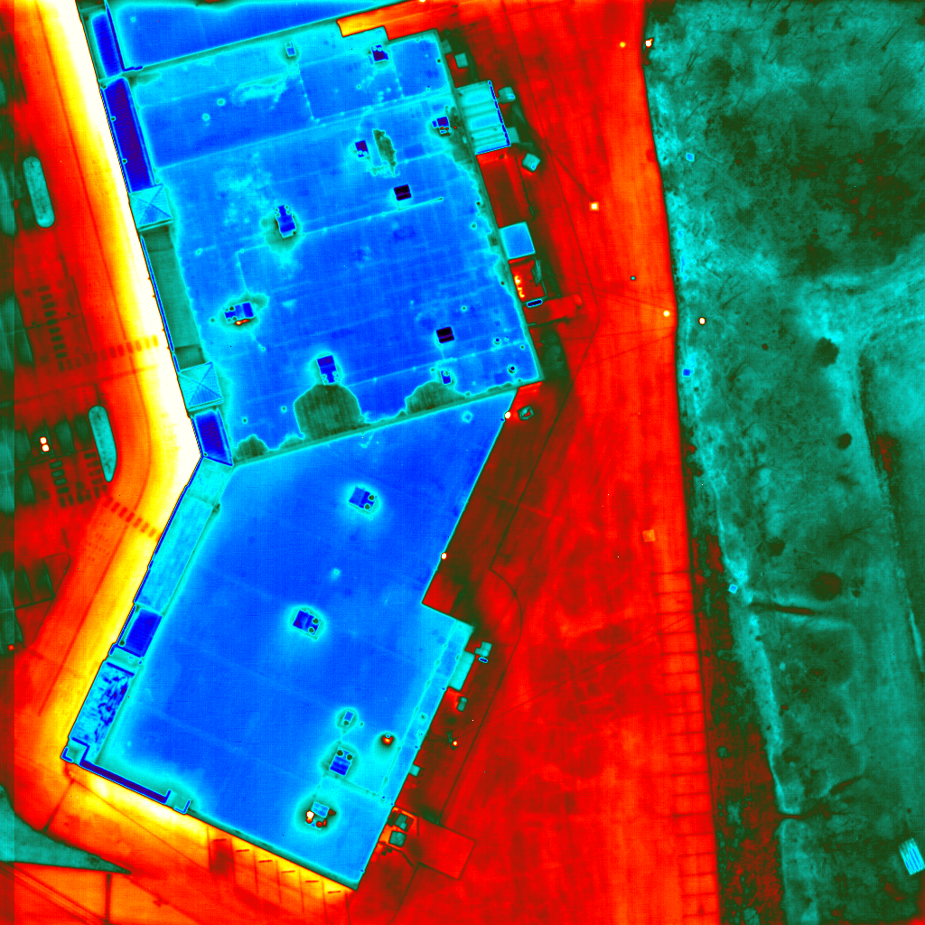
Visual photographs are taken earlier in the day or the next day. Both visual and aerial infrared scan images are used to do the analysis by overlaying the AutoCAD drawing of the roof ‘over’ the digitized photographs and thermographs. The drawings are created indicating areas of suspected moisture contamination.
HomeTech’s thermographers use infrared inspection tools in conjunction with state of the art nondestructive moisture meters to locate hidden defects and potential problems that a typical roof inspection company simply cannot show you. The process measures the thermal properties of a low slope insulated or flat roof to identify differences in temperature across the entire structure.
How An Aerial Infrared Scan Detects Moisture
During the daylight hours the heat of the sun warms the roof of your building and at night the roof radiates that heat back towards the sky. This is known as radiational cooling. Wet areas of the roof have a higher mass and because of this they will retain the heat longer. Meanwhile areas that are dry, which have a lower mass, cool more rapidly. Aerial Infrared Scan imagers detect and display the uneven heat dissipation and thereby accurately identifying areas of the roof needing attention.
Why Aerial Infrared Scan inspections should not be done through the use of inexperienced drone operators?
The topic and issue of drones has emerged rapidly in the world of thermal and infrared imaging, and many people are wondering why they are not being used more as a tool by thermographers. In theory, using a drone would be an inexpensive and efficient way for an infrared aerial survey to take an aerial glance of the roof from a high altitude as long as a small enough infrared camera would be able to mounted onto the drone. But many problems arise once drones take off.
Concerns of public safety and privacy issues are what are stopping the operation, but steps are being taken to override some restrictions. Most infrared thermography applications such as building sciences are conducted after sunset. There are restrictions and considerations related to flying an un-manned aircraft. There is also maintaining distance to spot ratio for a given infrared camera that leads to possibly missing, finding or understating them. Many drone operators attempting aerial infrared scan thermography have never walked a roof, nor do they understand the construction which entails how and when the infrared survey can be conducted along with the expected outcome.
The recorded difference in heat signatures shows the Thermographer problem areas such as:
- Moisture/Water intrusion
- Insulation deficiencies
- Flat or Insulated Roofing leaks
- Electrical systems
- Structural issues
- Mechanical Issues
- Building / Home Energy Loss
- Foundation deficiencies
- Plumbing obstructions
Aerial Infrared Scan Services
- Aerial Infrared Scans
- Aerial Infrared Roof Moisture Survey
- Aerial Infrared Steam Leak Survey
- Oblique Aerial Infrared Scans
Aerial Infrared Scan Images